When Floods Strike, Seconds Count: Inside The Multi-Hazard Early Warning App Recognized By HIEC, UNICEF & SAFE STEPS
Natural disasters are accelerating, but standard government alerts often arrive after water is already at your doorstep. Here’s how a telecommunications engineer built a sub-second multi-hazard radar to give vulnerable communities life-saving escape windows.
When a fault rupture propagates or tropical storm surges breach coastal revetments, human decision-making faces severe cognitive narrowing. The primary bottleneck during a catastrophe is rarely an absence of satellite sensors. Rather, it is the fragmentation, heavy bandwidth overhead, and friction of institutional portals.
Holding a Bachelor of Engineering in Telecommunication Engineering from Visveswaraiah Technological University (VTU) and drawing on over twenty years of directing commercial visual communication for multinational organizations, Mark D'Souza engineered HAZZY DRR to eliminate this interface failure. Built as a zero-bloat, sovereign GIS web application, HAZZY streams scientific hazard telemetry to standard mobile browsers in under 1.5 seconds under degraded network conditions.
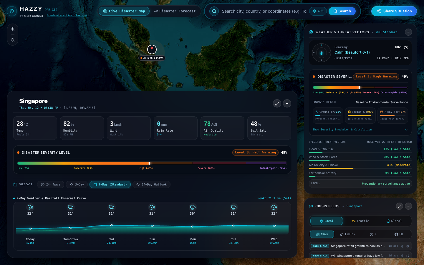
Top Problem Areas in Modern Disaster Risk Reduction
Emergency response infrastructure across the Asia-Pacific basin suffers from three structural weaknesses:
| Failure Vector | Conventional Government Portals | HAZZY DRR Architecture |
|---|---|---|
| Data Ingestion Speed | 15–45 min delay. Batch database updates, heavy server-side map tiling, login firewalls. | Sub-second streaming. Direct edge webhooks to USGS, NASA EONET, and Open-Meteo APIs. |
| Bandwidth Footprint | 12 MB to 28 MB. Bloated GIS tile sets that stall on congested 3G towers during power outages. | < 180 KB initial payload. Pure vector rendering, zero external tracking scripts, offline caching. |
| Verification & Noise | Unchecked social panic. Raw citizen posts circulate without baseline scientific corroboration. | Algorithmic Cross-Check. Seismic baseline depth comparison and historical recurrence validation. |
Industry Honors & International Competitions
HAZZY DRR has been independently audited, benchmarked, and awarded across multiple global technology competitions:
- HIEC Gold Award Winner: Awarded the Gold Award at HIEC for technical excellence in Disaster Risk Reduction software architecture, low-latency spatial data streaming, and zero-bloat emergency accessibility.
- UNICEF & MRANTI Impact Challenge Accelerator (MICA) — Top 10 Finalist: Jointly organized by UNICEF and MRANTI (Research Accelerator for Technology and Innovation) alongside Proficeo. The accelerator evaluated technologies aimed at community flood mapping, child protection, and localized climate literacy.
- SAFE STEPS D-Tech Awards — Top 20 Global Finalist: Created by the Prudence Foundation (community investment arm of Prudential plc) in partnership with the International Federation of Red Cross and Red Crescent Societies (IFRC), Amazon Web Services (AWS), and the Lenovo Foundation to identify and scale life-saving disaster tech.
Automated Editorial Cards & Crisis Infographics
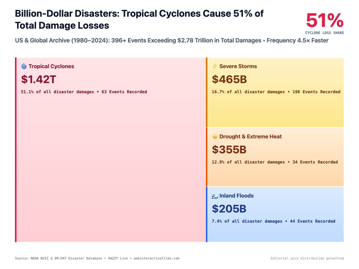
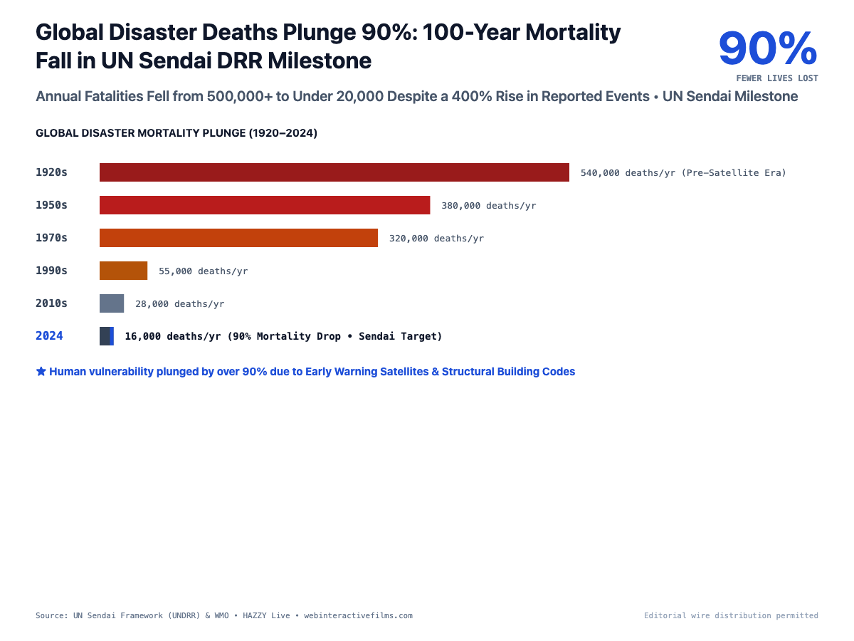
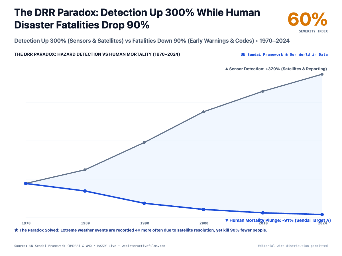
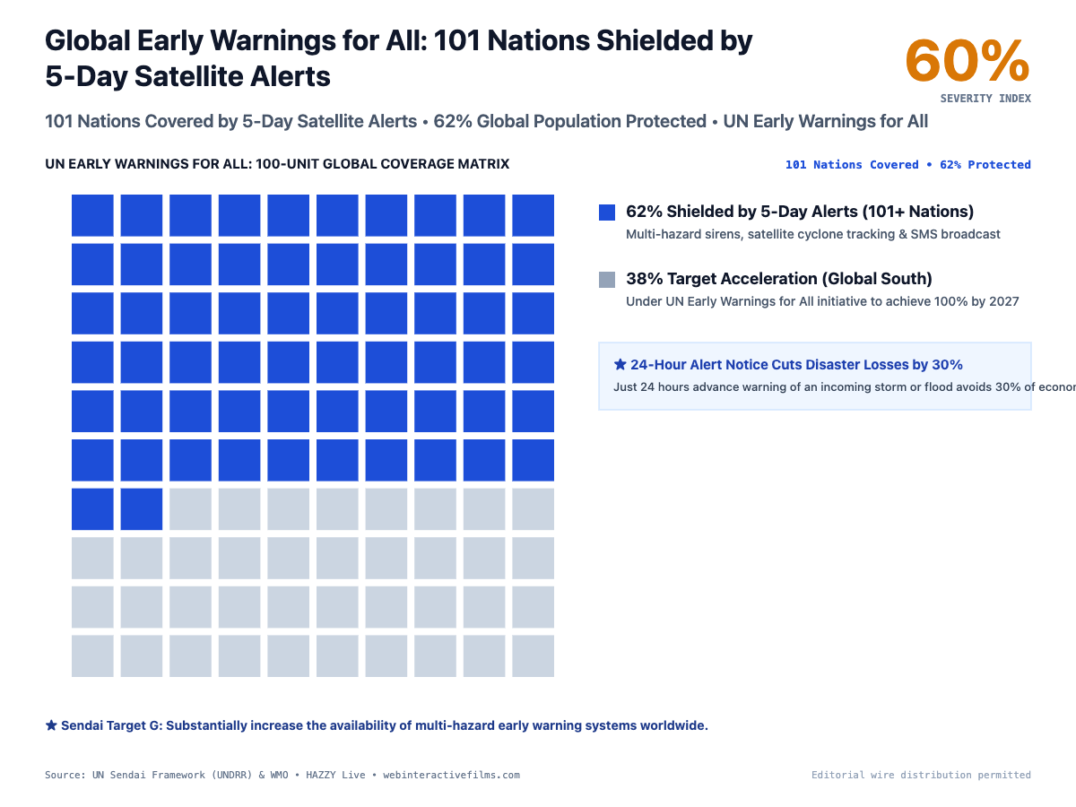
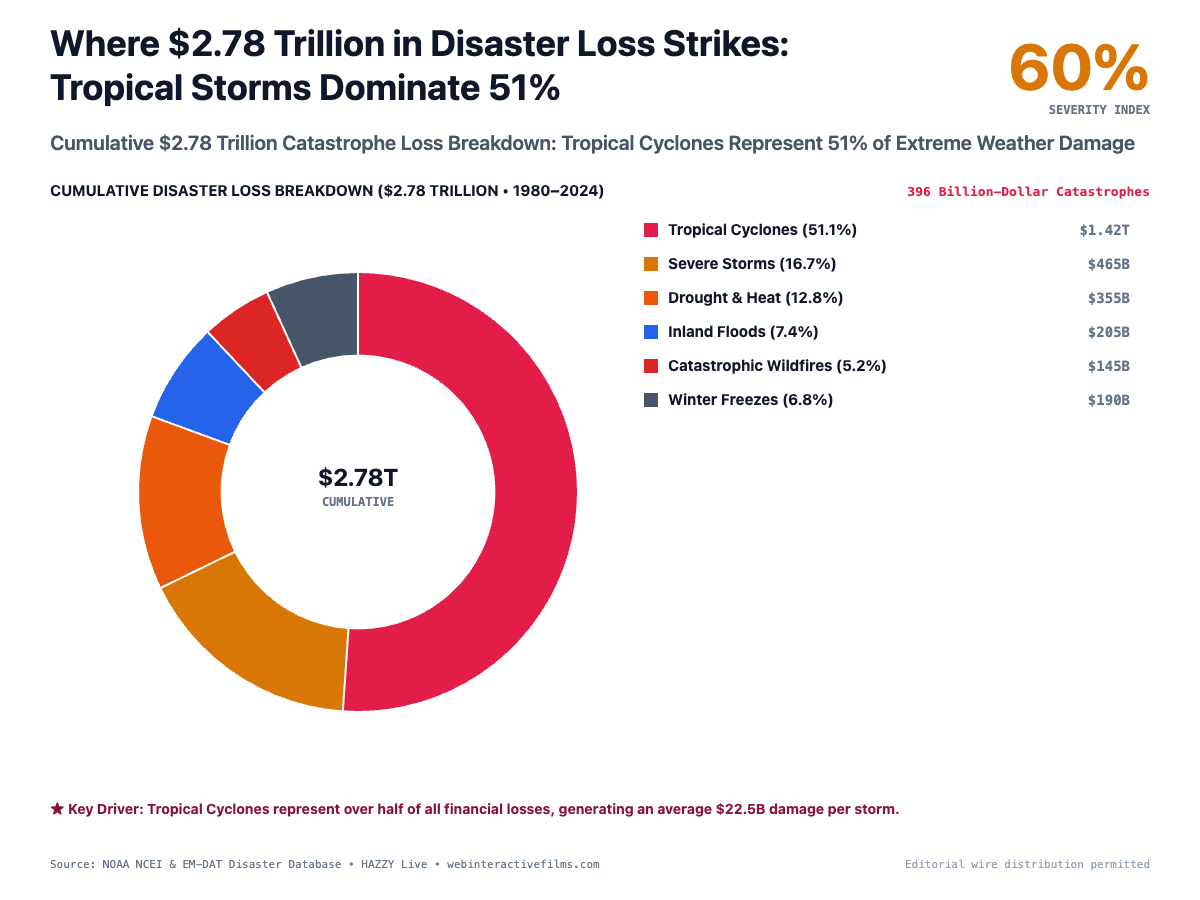
During active events, HAZZY DRR automatically generates standardized 4:3 high-contrast editorial graphic cards directly in browser canvas memory. These cards synthesize complex geophysical models into verified news wire plates for municipal broadcast and social distribution:
Lean Business Model Canvas
- Disparate hazard data sources with 15–45 min latency.
- Bandwidth-heavy map tiles fail on rural cell towers.
- Unverified social media rumors trigger panic or apathy.
- Municipal civil defense and emergency operations centers.
- Reinsurance companies modeling catastrophe exposure.
- Humanitarian NGOs (UNICEF, IFRC, Red Crescent).
- Infrastructure operators (highways, rail, ports).
- Sub-1.5s emergency GIS operable over low-bandwidth 3G.
- Automated 4:3 canvas editorial card dispatch engine.
- One-click Situational Report (SitRep) deep-link generator.
- B2G Emergency Operations Center (EOC) dedicated integrations.
- Parametric disaster insurance telemetry validation API.
- Sovereign nation custom alerting deployment contracts.
- Edge compute hosting and cloud vector caching nodes.
- High-frequency NOAA / NASA / USGS API bandwidth pipelines.
- Automated uptime monitoring and failover clusters.
- Dual VTU engineering rigor and 20+ year director UX mastery.
- Recognition from UNICEF, MRANTI, and SAFE STEPS / IFRC.
- Proprietary 4:3 news-wire canvas rendering engine.
Platform Access & Verification
The live production build of HAZZY DRR is permanently accessible to the public without paywalls or account creation at hazzy-drr.vercel.app ↗.